

Geography trivia is a fun way to learn about the world while testing your knowledge. From capitals and landmarks to natural wonders, this article explores 10 engaging questions that cover a wide range of topics. Here's what you'll discover:
- Capital of Australia: Canberra, a city chosen to resolve the Sydney-Melbourne rivalry.
- Golden Gate Bridge: Found in San Francisco, California, and known for its iconic International Orange color.
- Tallest Mountain: Mount Everest, standing at 29,031.7 feet above sea level.
- Longest U.S. River: The Missouri River, stretching 2,341 miles.
- Hottest Temperature: Death Valley, California, recorded a scorching 134°F in 1913.
- Most Official Languages: Bolivia leads with 37 official languages.
- Smallest Country: Vatican City, covering just 0.17 square miles.
- Largest Ocean: The Pacific Ocean, spanning 63.8 million square miles.
- Most Populated City: Tokyo, Japan, with over 37 million residents in its metropolitan area.
- Famous Rock Formation: Uluru in Australia, a sacred site for the Aṉangu people.
These questions highlight interesting facts about geography, history, and human achievements. Whether you're preparing for trivia night or just curious, this list combines engaging details with easy-to-remember information. Let’s dive into the wonders of the world!
40 Epic GEOGRAPHY PUB QUIZ & TRIVIA Questions for you to explore!
1. What is the capital of Australia?
Answer: Canberra
Want 75+ More Trivia Questions Like These?
Our themed packs come with answer keys, host sheets, and PowerPoint — print and play tonight. $15.
Browse Themed PacksThis question often trips people up. Many instinctively guess Sydney or Melbourne, as they're the most well-known and populous cities in Australia. However, the actual capital is Canberra, a city with a population of 473,855.
The choice of Canberra as the capital stems from a historic rivalry between Sydney and Melbourne. Neither city could agree on which should hold the honor, so a compromise was reached: a new, purpose-built city would become the capital. This decision laid the foundation for one of Australia's most fascinating trivia facts.
In October 1908, the House of Representatives chose the Yass-Canberra site over Dalgety, meeting specific criteria for the capital's location. This not only ended the Sydney-Melbourne debate but also highlighted Canberra's strategic importance.
"I name the capital of Australia Canberra"
These were the words of Lady Denman on March 12, 1913, during the official naming ceremony. Interestingly, in 1912, the public submitted hundreds of suggestions for the capital's name.
The decision to position Canberra inland was largely influenced by security concerns. Leaders wanted to reduce the risks associated with coastal locations. Designed with geometric precision by the architects Walter Burley Griffin and Marion Mahony Griffin, the city reflects meticulous planning. Adding to its charm, Canberra is the only mainland Australian city where you can see snow-capped mountains during much of the winter.
Understanding these details not only makes for a great trivia nugget but also offers a glimpse into the thoughtful planning behind Canberra's creation.
2. Which U.S. city is home to the Golden Gate Bridge?

Answer: San Francisco, California
The Golden Gate Bridge, a symbol of American ingenuity and one of the most recognizable landmarks in the country, is located in San Francisco, California. Stretching across the Golden Gate Strait, this suspension bridge connects San Francisco to Marin County. Its striking design and rich history make it a defining feature of the San Francisco skyline.
When it opened in 1937, the Golden Gate Bridge was a marvel of engineering. At 8,980 feet long (or 1.7 miles), with a main span of 4,200 feet and towers soaring 746 feet high, it claimed the title of the longest and tallest suspension bridge in the world at the time. Its distinctive International Orange color wasn’t just chosen for aesthetics - it helps the bridge stand out in San Francisco’s frequent fog.
Frommer's travel guide aptly captures its allure:
"possibly the most beautiful, certainly the most photographed, bridge in the world."
Today, the bridge is a vital transportation link, carrying around 112,000 vehicles daily via U.S. Route 101 and California State Route 1. It also welcomes pedestrians and cyclists, offering breathtaking views of the Bay Area. With 80,000 miles of wire in its suspension cables and a total weight of 887,700 tons, the Golden Gate Bridge is built to endure, even standing strong against magnitude 8 earthquakes.
3. What is the tallest mountain in the world?
Answer: Mount Everest
Mount Everest, straddling the border of Nepal and Tibet, reaches a staggering height of 29,031.7 feet (8,848.86 meters) above sea level. This official measurement, taken in 2020 with advanced GPS and radar tools, also notes its rock base at 29,017 feet (8,844.43 meters). Its towering presence has been consistently recognized, as highlighted in this description:
"Mount Everest, mountain on the crest of the Great Himalayas of southern Asia that lies on the border between Nepal and the Tibet Autonomous Region of China... Reaching an elevation of 29,032 feet (8,849 meters), Mount Everest is the highest mountain in the world."
What makes Everest even more fascinating is its growth. The Indian tectonic plate pushes northward at about 2 inches (5 cm) annually, causing the summit to rise by approximately 1.6 to 1.7 inches (40–44 mm) each year. This relentless upward shift places Everest's peak firmly in the infamous "death zone", which begins above 26,000 feet (7,925 meters). The harsh conditions of this zone, marked by dangerously low oxygen levels, have tragically claimed 340 lives as of May 2024.
While other mountains, such as Mauna Kea, may surpass Everest in height when measured from base to peak, Everest holds the title as the highest point above sea level.
4. Which river is the longest in the United States?
Answer: The Missouri River
The Missouri River claims the title of the longest river in the United States, spanning an impressive 2,341 miles (3,767 km). It edges out the Mississippi River by just one mile, as the latter measures 2,340 miles (3,766 km). The Missouri eventually merges with the Mississippi near St. Louis, Missouri, and together, they form the Mississippi-Missouri river system, which ranks as the fourth longest in the world.
The Missouri River has a reputation for being unpredictable and full of surprises. Writer George Fitch once described it with a touch of humor:
"There is only one river with a personality, a sense of humor, and a woman's caprice; a river that goes traveling sidewise, that interferes in politics, rearranges geography, and dabbles in real estate; a river that plays hide and seek with you today and tomorrow follows you around like a pet dog with a dynamite cracker tied to his tail. That river is the Missouri."
This vivid description captures the river's history of shifting courses and sudden flooding. Often referred to as the "Center of Life" for the Great Plains, the Missouri River has been a lifeline for exploration, trade, transportation, and agriculture for thousands of years. Its watershed covers about one-fourth of the agricultural land in the United States, making it a cornerstone of the nation's farming economy.
The river also boasts a rich historical significance, flowing through key cities such as Great Falls, Montana; Bismarck, North Dakota; Omaha, Nebraska; Kansas City, Missouri; and St. Louis, Missouri, where it meets the Mississippi. Since the time of Paleo-Indians, the Missouri has served as a critical route for transportation and commerce. Its legacy is as vast and enduring as the waters that carve their way through the heart of America.
5. What is the hottest recorded temperature in Death Valley, California?
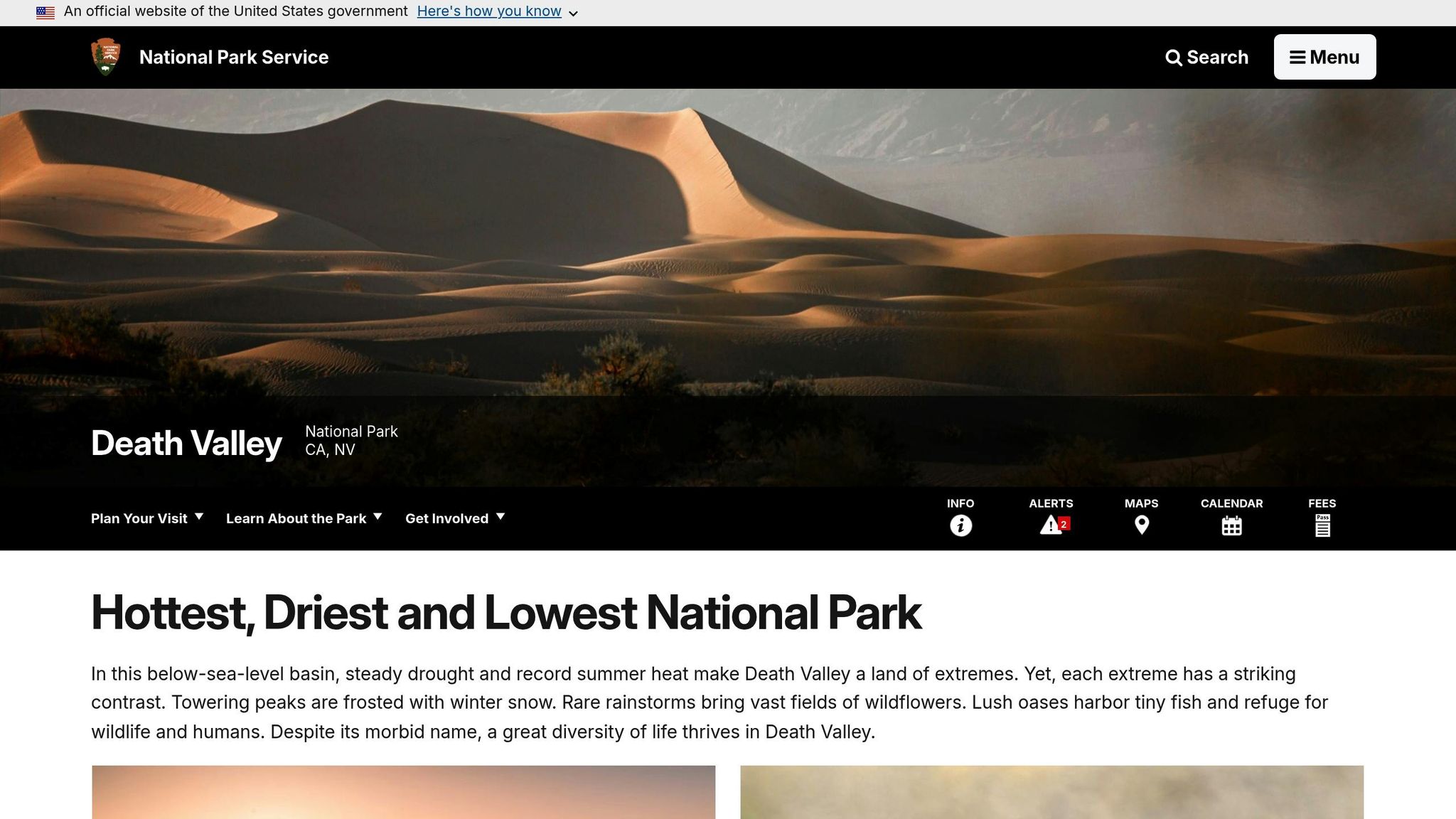
Answer: 134°F (57°C)
On July 10, 1913, Death Valley set the record for the hottest air temperature ever measured: a scorching 134°F (57°C). This occurred during an intense heat wave where temperatures stayed at or above 129°F (54°C) for five consecutive days. To put this into perspective, it's 9 degrees hotter than the peak temperatures recorded during the Dust Bowl of the 1930s and 8 degrees above Phoenix's all-time high.
Why Death Valley Gets So Hot
Death Valley's extreme heat is no accident - it's a result of its unique geography. Sitting 282 feet below sea level, this desert lies in a basin surrounded by steep mountains, which trap heat like a natural oven. With only about 2 inches of rain each year and minimal vegetation, the sun's energy directly heats the ground and air. As a result, Death Valley experiences an average of 147 days per year where temperatures exceed 100°F, and 23 days where they surpass 120°F.
Ground vs. Air Temperatures
While the 134°F record refers to air temperature, ground temperatures in Death Valley are even more extreme. At Furnace Creek, the ground temperature reached a blistering 201°F on July 15, 1972.
Recent Temperature Controversies
Some meteorologists have questioned the accuracy of the 1913 record, but the World Meteorological Organization still recognizes it as the official highest air temperature ever recorded. More recently, Death Valley hit 130°F on August 16, 2020, and again on July 9, 2021, though these readings remain unverified. Whether or not these newer records are confirmed, they highlight the incredible forces at work in one of the planet's hottest regions.
Death Valley's extreme temperatures are a striking reminder of the Earth's raw and powerful natural phenomena.
sbb-itb-46dff1a
6. Which country has the most official languages?
Answer: Bolivia
Bolivia leads the world with 37 official languages, as outlined in its Constitution. This remarkable diversity highlights the country's dedication to preserving its indigenous heritage and cultural identity.
Multilingual Comparisons
Bolivia's linguistic landscape is unmatched, but other nations also embrace multilingualism. India ranks second with 22 official languages, followed by Zimbabwe with 16 and South Africa with 12. Even within South America, Bolivia stands apart. For instance, Peru, another linguistically rich country, recognizes 32 official languages.
| Country | Number of Official Languages |
|---|---|
| Bolivia | 37 |
| India | 22 |
| Zimbabwe | 16 |
| South Africa | 12 |
Why Bolivia Recognizes So Many Languages
Bolivia's 2009 Constitution reflects a deep respect for its indigenous roots. Spanish is an official language, but so are all the indigenous languages spoken across the nation. Among these, Quechua and Aymara are the most widely spoken.
"Having various official languages contributes to the sense of belonging a resident can have all while respecting a nation's history and its native population." – Ad Astra Social Team
How It Works Day-to-Day
This multilingual policy isn't just symbolic - it shapes how the government operates. Bolivia's Constitution requires official communications to be provided in Spanish and at least one indigenous language, depending on local needs. Additionally, the government prioritizes indigenous language education to preserve traditions and strengthen native communities.
Bolivia's approach serves as a powerful reminder of how a nation can honor its history and diversity through language, weaving together its cultural and geographical identity in a way that stands out worldwide.
7. What is the smallest country in the world by area?
Answer: Vatican City
Vatican City holds the title of the world's smallest country, covering just 0.17 square miles (0.44 km²). This independent city-state is entirely surrounded by Rome, Italy.
Just How Small Is Vatican City?

To put its size into perspective, you could walk across the entire country in about 10 minutes. With a population of just over 800 residents, it’s tiny but mighty. The country is enclosed by high walls and protected by the renowned Papal Swiss Guard. Latin remains its primary liturgical language.
For scale, Russia, the largest country in the world, is nearly 39 million times bigger than Vatican City. Even New Delhi, the capital of India, is about 1,000 times larger.
How Vatican City Compares to Other Small Countries
Vatican City's size becomes even more striking when compared to other small nations. Among the 17 smallest countries in the world, all of which are under 200 square miles, Vatican City is the tiniest. Monaco, for example, is nearly five times larger at 0.8 square miles, while Nauru, at 8 square miles, is ten times Monaco's size.
| Country | Area (Square Miles) |
|---|---|
| Vatican City | 0.17 |
| Monaco | 0.8 |
| Nauru | 8 |
| Tuvalu | 10 |
| San Marino | 24 |
Its dual role as both a religious hub and a sovereign nation makes Vatican City a fascinating geographical outlier.
8. Which ocean is the largest by surface area?
Answer: Pacific Ocean
When it comes to sheer size, the Pacific Ocean stands unmatched as the largest and deepest ocean basin on the planet. Spanning an incredible 165.25 million km² (63.8 million sq mi) [55,56], it covers more than 30% of Earth's surface. That’s nearly one-third of the planet! In terms of water coverage, it accounts for 46% of Earth's water surface and 32% of its total area. To put it into perspective, the Pacific contains nearly half of the world’s ocean water. While the combined landmass of all continents and islands measures about 148.94 million square kilometers, the Pacific stretches beyond that, covering 165.25 million square kilometers. Its scale is simply staggering.
How the Pacific Compares to Other Oceans
The Pacific’s dominance becomes even clearer when stacked against the other ocean basins. It holds nearly twice the water volume of the Atlantic Ocean, which ranks as the second-largest ocean. In terms of surface area, the Pacific is about 1.5 times larger than the Atlantic, and by volume, it is nearly three times greater.
| Ocean | Area (sq mi) | Volume (cubic mi) | Average Depth (ft) |
|---|---|---|---|
| Pacific Ocean | 63.8 million | 160.7 million | 13,025 |
| Atlantic Ocean | 32.2 million | 74.5 million | 11,962 |
| Indian Ocean | 27.2 million | 63.4 million | 12,274 |
| Southern Ocean | 8.5 million | 17.2 million | 10,728 |
| Arctic Ocean | 6.0 million | 4.5 million | 3,953 |
The Pacific also takes the crown for depth, averaging around 13,000 feet (4,000 meters). Its deepest point, Challenger Deep in the Mariana Trench, plunges to over 36,000 feet (11,000 meters) below the surface. It’s a realm of extremes, showcasing the awe-inspiring scale and mystery of our planet’s largest ocean.
9. What is the most populated city in the world?
Answer: Tokyo, Japan
Tokyo holds the title as the world's most populated urban area, with a staggering 37,036,200 residents as of 2025. This number represents the population of the entire metropolitan area, which spans an impressive 5,200 square miles. It's a testament to Tokyo's sprawling urban landscape and its role as a global hub for culture, business, and innovation.
Tokyo and How It Stacks Up Against Other Megacities
Tokyo’s dominance is even more apparent when compared to other major urban centers:
| Rank | City | Country | 2025 Population |
|---|---|---|---|
| 1 | Tokyo | Japan | 37,036,200 |
| 2 | Delhi | India | 34,665,600 |
| 3 | Shanghai | China | 30,482,100 |
| 4 | Dhaka | Bangladesh | 24,652,900 |
| 5 | Cairo | Egypt | 23,074,200 |
Asian cities dominate the list of the world’s largest urban areas, reflecting the region's rapid urbanization and economic development. Following Tokyo, Delhi, India, comes in second with 34,665,600 residents, while Shanghai, China, secures third place with 30,482,100 people.
For some perspective, Tokyo’s population is over four times larger than New York City’s, which ranks 52nd globally. Currently, there are 37 megacities worldwide, each with populations exceeding 10 million.
The Future of Population Rankings
While Tokyo leads today, demographic trends suggest that change may be on the horizon. By 2030, New Delhi is expected to add another 10 million residents, potentially surpassing Tokyo as the most populated city. Meanwhile, Japan’s aging population and declining birth rates could lead to a gradual reduction in Tokyo’s population. In fact, the Japanese government has already introduced incentives to encourage residents to move from Tokyo to rural areas.
Tokyo’s current size and influence are unparalleled, but the shifting dynamics of global urbanization may soon reshape these rankings.
10. What is the name of the famous rock formation in Australia's Northern Territory?
Answer: Uluru (also known as Ayers Rock)
Uluru, a symbol of Australia's natural beauty, stands 1,142 feet (348 m) tall, stretches about 2.2 miles (3.6 km) in length, 1.5 miles (2.4 km) in width, and boasts a circumference of roughly 5.8 miles (9.4 km). Its sheer size and unique presence make it one of the country's most recognizable landmarks.
A Deeply Spiritual Landmark
For the Aṉangu people, Uluru is much more than a natural wonder; it is a sacred site woven into their identity. Their traditions, rooted in over 60,000 years of history, revolve around Tjukurpa, a concept that embodies their laws, stories, and spiritual beliefs. According to Aṉangu lore, Uluru was shaped by ancestral beings during the Dreaming. Surrounding the rock are over 40 sacred sites, including springs, caves, and ancient rock art, each carrying its own story and significance.
Dual UNESCO Recognition
Uluru's significance is both cultural and geological. Formed around 550 million years ago, it has earned dual UNESCO World Heritage status - first in 1987 for its natural features and again in 1994 for its cultural importance. This dual acknowledgment highlights its status as a site of global importance.
A Natural Chameleon
One of Uluru's most captivating features is its ability to change color throughout the day. Its reddish hue, caused by iron oxide in the sandstone, glows bright red at sunrise, shifts to rusty orange during the day, and deepens into rich tones at sunset. Rainfall adds another layer of drama, transforming its surface into shades of dark burgundy, silver, or even black.
Today, the Aṉangu people work hand-in-hand with park authorities to manage Uluru-Kata Tjuta National Park. Their efforts ensure that Uluru's cultural and natural heritage remains protected for generations to come.
Conclusion
Geography trivia questions are a fantastic way to test your knowledge while creating memorable and engaging experiences with any group. This collection offers not just a challenge but also an opportunity to appreciate the incredible diversity of our planet. Whether you're planning a family game night, a team-building event at work, or just want to spice up your trivia skills, these questions can kickstart a journey through the wonders of geography.
What makes geography trivia so appealing is its universal connection. Everyone has ties to places, whether through travel, heritage, or simple curiosity about the world. From the towering heights of Mount Everest to the iconic presence of Uluru, these questions touch on a broad spectrum of topics, offering something for every knowledge level.
A successful trivia session hinges on knowing your audience. Mixing familiar landmarks with more obscure facts about physical geography or cultural significance keeps everyone engaged and ensures a lively atmosphere. It’s all about balance - keeping the game both fun and challenging.
Beyond entertainment, geography trivia also educates. Each question can spark discussions about different cultures, environmental issues, or historical events. For instance, learning that Death Valley once hit a scorching 134°F (56.7°C) or discovering the cultural significance of Uluru to the Aṉangu people transforms trivia into a deeper appreciation for the world around us.
Whether you’re organizing your next trivia night or simply expanding your knowledge, these geography questions are your gateway to hours of fun and discovery. The world is full of fascinating stories and details - let these questions inspire your next adventure with Cheap Trivia!
FAQs
Why is Canberra the capital of Australia instead of larger cities like Sydney or Melbourne?
Canberra became Australia's capital as a way to resolve the competition between Sydney and Melbourne, the nation's two largest cities. It was picked as a neutral location, ensuring neither city was given preference, and symbolizing a step toward national unity.
The site itself was chosen for practical reasons as well. It met the requirement of being at least 100 miles from Sydney and provided ample space for future growth. This decision highlights Australia's commitment to fostering a sense of balance and cohesion across the country, steering clear of favoritism between its key urban hubs.
Why is Death Valley, California, considered the hottest place on Earth?
Death Valley experiences some of the planet's most extreme heat due to a mix of unique geographical and climatic factors. Sitting 282 feet below sea level, its long, narrow basin acts like a natural oven, trapping hot air. Surrounding mountains prevent cooler air from flowing in, while the area's dry climate and intense solar radiation push temperatures even higher. These elements combine to create the sweltering conditions Death Valley is infamous for.
How does Bolivia handle communication and education with its 37 official languages?
Bolivia acknowledges an impressive 37 official languages, as specified in its constitution. Among them, Spanish stands out as the primary language for government operations and education, making it a unifying tool across the nation. Alongside Spanish, indigenous languages like Quechua and Aymara hold official status and remain vital in many regional and local communities.
To embrace its multilingual heritage, Bolivia actively promotes bilingual education in regions where indigenous languages are widely spoken. This initiative not only helps preserve these languages but also ensures inclusivity and mutual understanding in a country rich with linguistic and cultural diversity.